


The Watershed Association of the Tellico Reservoir was formed to protect and preserve the environment in the Tellico watershed.
As a part of this mission, one of its committees, the Water Quality Improvement Committee, has undertaken several long-term studies to look at the clarity of the Tellico Reservoir due to concerns about the possible increase in “greening” of the lake.
Greening, resulting from growth of algae, is affected by runoff from agricultural and residential nutrient pollution. These concerns have arisen from the increase in new homes in the area around the watershed, resulting in the greater use of fertilizers that run off into the reservoir.
Individuals who have lived around Tellico Lake for nearly 30 years have noticed a change in the color of the water from blue to grey/green. WQIC has decided to conduct a long-term study of the lake’s water to see if negative trends can be found and then to find appropriate solutions to reverse them.
After intense rain storms, the area around the mouth of in-flowing streams turns brown for a few days because of soil runoff. Change in color from blue to grey/green is an indication of higher levels of algae. Algae are a diverse group of aquatic organisms that have the ability to conduct photosynthesis.
Nutrients like phosphorus and nitrogen encourage the growth of plants and grass on land and, when rain water — stormwater runoff — washes them into the lake, their presence there encourages the growth of algae and other unwanted vegetation.
In 2018, WQIC began a program to monitor the clarity of water in the Tellico Reservoir. Clarity depends on materials dissolved or suspended in the water, such as sediment, tannins from bark or plant tissue and phytoplankton, which are microscopic plants that grow in the water. Clarity is an indicator of the overall health of the lake. Water clarity can be measured fairly easily, gives an indication of the present quality of the water in the Tellico Reservoir and can be used to track changes over time.
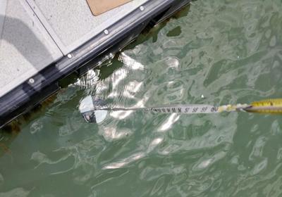
Clarity is measured using a Secchi disk, which is an 8-inch circular disc painted black and white in a checkerboard pattern. The disk is lowered into the water. When the checkerboard pattern disappears, the depth level is recorded and is referred to as the “Secchi depth.” The greater the depth the light penetrates into the water, the farther down into the water you can see the Secchi disk.
In 2020, clarity was measured at the Toqua Boat Ramp, Fort Loudoun State Park, the Yacht Club guest dock and Morganton Boat Ramp on Baker Creek. The Secchi depth averages for these sites were Toqua Boat Ramp 73 inches, Fort Loudoun (at kayak launch pier) 75 inches, Yacht Club 64 inches and Morganton Boat Ramp 37 inches. Toqua and Fort Loudoun waters were reasonably clear, while Morganton was less clear.
The Tennessee Valley Authority collects information on water quality of the Tellico Reservoir at miles 1 and 15 every other year and have been doing so since 1993. The TVA also use a Secchi disk to measure water clarity. Volunteers with the WQIC measure Secchi depth at more locations and more frequently than TVA. WATeR’s goal is to observe changing trends as early as possible.
WATeR is also studying the lake’s biological growth status. Science terminology refers to this as the “trophic state” of water. All lakes naturally “age” over time and generally water quality decreases. Nutrients such as nitrogen and phosphorus, together with factors such as temperature and light, affect the abundance of algae or biological growth.
Bodies of water are classified according to their biological productivity or growth. Low-productivity waters are “oligotrophic” and generally are very clear, whereas waters with high biological growth are “eutrophic” and can be turbid and green in color. “Mesotrophic” waters are in between. Water with high productivity is referred to as “hyper-eutrophic.” In these waters, green scum can form from dense algal blooms and the water can be unsightly, smell bad and sometimes be toxic to humans and fish.
WQIC collected data for trophic determination at three sites in the main stem of the reservoir, mid-lake at the Yacht Club and up-lake sites on the Little Tennessee River and Tellico River arms. Data was also collected in three of the reservoir embayments at Bat Creek, Baker Creek and Fork Creek. Embayments are shallow coves where small streams enter the lake.
Tellico Reservoir would be defined as being mesotrophic. The three embayments would be defined as borderline between mesotrophic and slightly eutrophic.
WQIC also had the composition of the phytoplankton community assessed as part of the study. Seventy-six species of phytoplankton were identified. Diatoms — a species of algae that are encased in a glass (silica) sphere — or blue-green algae, were the dominant phytoplankton species in all of the sites, except in the Little Tennessee River arm of the upper lake where green algae were most numerous.
These results indicate the shallow areas feeding into the Tellico Reservoir have more growth or sediment present and need to be followed to determine their influence on the water quality of the reservoir as a whole.
For more information on the two studies, Tellico Reservoir Water Clarity Monitoring Program: 2018-2020 and The Trophic State of Tellico Reservoir in 2020, visit www.tellico water.org.


